D - Dense station swath D
The AlpArray network is augmented by several swaths of closely spaced stations (c. 12 km apart) that will be deployed for 2 years across key areas of the orogen and are embedded in the AlpArray network. The ~12 km spacing along the swaths will provide 10-15 km resolution of structures down to ~200 km depth. The German effort concentrates on swaths C and D (Figs. 1, 2).
Swath D (Activity D) – crosses the junction of Central, Eastern and Southern Alps along the tip of the eastern Adriatic indenter. It comprises covers part of the Moho gap in the Eastern Alps (Fig. 2c) and the slab gap between Central and Eastern Alps (Fig. 2d). It complements the orogen-perpendicular EASI swath of Czech, Austrian and Swiss partners, as well as the TRANSALP section (Fig. 2a), thus providing optimal coverage of structures in the crust and upper mantle related to a possible switch in subduction polarity and to orogen-parallel motion of the orogenic crust (Themes 1, 3). Swath D will image prominent crustal and lithospheric structures (e.g., Periadriatic Fault System) down to the base of the crust and/or lithosphere, allowing surface structures to be linked with the deeper structures targeted by the AlpArray station network (Theme 4).
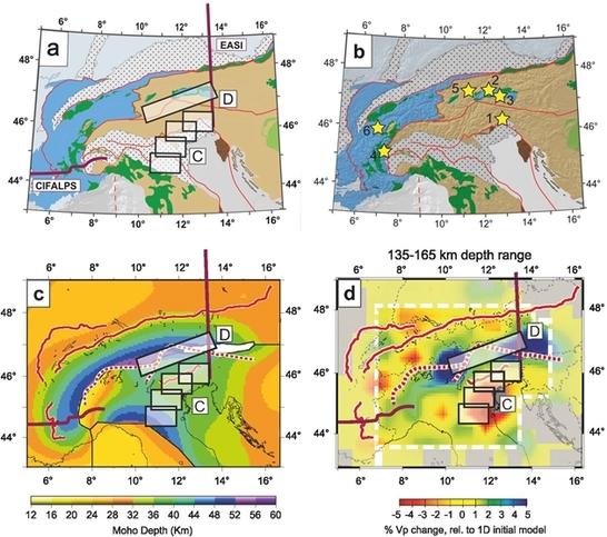
Figure 2: (a) Tectonic map of Alps with locations of current and new passive seismic experiments: C and D - German swaths in this study, EASI - Czech-Austria-Swiss swath, CIFALPS - China-Italy-France swath; (b) Tectonic map with numbered stars showing potential targets of geological investigation at the surface (see text); (c) Moho depth map (Spada et al. 2013) and (d) tomographic depth slice as in Fig. 2b (after Lippitsch et al. 2003) with new seismic profiles and swaths in the AlpArray experiment.
